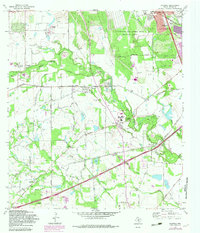
1967 Map of Macdona
USGS Topo · Published 1983About this map
The Medina River carves a winding path through this corner of Bexar County, separating the residential growth of Macdona from the rural reaches of the Von Ormy Field. This landscape is a patchwork of ranching heritage and the post-war expansion of San Antonio, where large holdings like the Straus Medina Ranch and Rio Vista Farms exist alongside the industrial footprint of the Lackland Air Force Base Training Annex.
Find a feature on this map
70 named features on this map. Tap any name to fly to it.
Don’t see what you’re looking for? This feature index may not catch every label — zoom into the map to look around manually.
Map Details
Editions of this 1967 Macdona Map
3 editions found
Other maps of this area

1942 · Natalia
USGS Topo · 1:62,500

1953 · Culebra Hill
USGS Topo · 1:24,000

1953 · San Antonio West
USGS Topo · 1:24,000

1953 · Terrell Wells
USGS Topo · 1:24,000

1953 · Macdona
USGS Topo · 1:24,000

1954 · San Antonio
USGS Topo · 1:250,000

1957 · San Antonio
USGS Topo · 1:250,000

1958 · La Coste
USGS Topo · 1:24,000

1958 · Somerset
USGS Topo · 1:24,000

1958 · La Coste NE
USGS Topo · 1:24,000