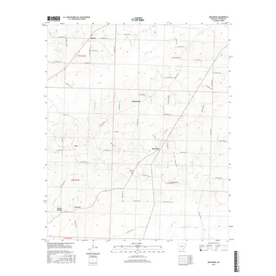
2017 Map of Macedonia
USGS Topo · Published 2017About this map
Macedonia and Harmony serve as central nodes in this rural section of Columbia County, where a network of county roads connects long-established farming communities. The landscape is defined by the drainage systems of Big Cr and Hurricane Cr, which carve through the terrain near the prominent Rocky Mound. Local history is anchored at the Macedonia Cem, situated near the crossroads that link Philadelphia and Hunt. The settlement pattern follows the numerous creeks and branches, such as Mill Cr and Horsehead Cr, reflecting a tradition of homesteads situated along these water sources and the local timber or agricultural lands that sustain them. This 2017 survey shows the enduring footprint of these small Arkansas settlements, from the northern cluster at Dodson to the southern reaches of the county line, maintaining their identity through well-defined road networks and shared community landmarks.
Find a feature on this map
61 named features on this map. Tap any name to fly to it.
Don’t see what you’re looking for? This feature index may not catch every label — zoom into the map to look around manually.
Map Details
Editions of this 2017 Macedonia Map
This is the sole edition of this map. No revisions or reprints were ever made.
Other maps of this area

1953 · El Dorado
USGS Topo · 1:250,000

1957 · El Dorado
USGS Topo · 1:250,000

1958 · El Dorado
USGS Topo · 1:250,000

1960 · El Dorado
USGS Topo · 1:250,000

1960 · Bussey
USGS Topo · 1:24,000
1960 · Taylor
USGS Topo · 1:24,000

1960 · Walkerville
USGS Topo · 1:24,000

1960 · Macedonia
USGS Topo · 1:24,000

1966 · Calhoun
USGS Topo · 1:24,000

1968 · Buckner
USGS Topo · 1:24,000