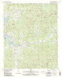
1988 Map of Macedonia
USGS Topo · Published 1988About this map
Chatuge Lake dominates the western edge of this mountain landscape, its intricate shoreline following the Hiwassee River valley and its various tributaries like Shoal Creek and Raccoon Creek. The settlement of Hiawassee serves as a primary hub, while smaller communities like Macedonia, Osborn, and Titus are connected by a network of winding mountain roads and creek-side paths. The map reveals a deeply rooted social geography, marked by numerous rural congregations and burial grounds such as Bell Scene Ch, Upper Bell Ch, and Lower Bell Creek Cem.
Find a feature on this map
178 named features on this map. Tap any name to fly to it.
Don’t see what you’re looking for? This feature index may not catch every label — zoom into the map to look around manually.
Map Details
Editions of this 1988 Macedonia Map
2 editions found
Other maps of this area

1886 · Dahlonega
USGS Topo · 1:125,000

1892 · Dahlonega
USGS Topo · 1:125,000

1896 · Dahlonega
USGS Topo · 1:125,000

1903 · Dahlonega
USGS Topo · 1:125,000

1935 · Osborn
USGS Topo · 1:24,000

1935 · Rainbow Springs
USGS Topo · 1:24,000

1935 · Shooting Creek
USGS Topo · 1:24,000

1935 · Wayah Bald
USGS Topo · 1:48,000

1935 · Hightower Bald
USGS Topo · 1:24,000

1935 · Tray Mountain
USGS Topo · 1:24,000