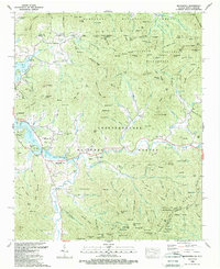
1988 Map of Macedonia
USGS Topo · Published 1988About this map
Chatuge Lake dominates the landscape of this Georgia and North Carolina border region, its intricate shoreline carving into the foothills of the Nantahala National Forest and Chattahoochee National Forest. This late 20th-century topography reveals a community structured around both the reservoir and the older valley settlements like Hiawassee and Macedonia. The map documents a blend of rural mountain life and educational infrastructure, notably the County Comprehensive Sch and various family-linked sites such as the Osborn Cem and Carter Cem.
Find a feature on this map
191 named features on this map. Tap any name to fly to it.
Don’t see what you’re looking for? This feature index may not catch every label — zoom into the map to look around manually.
Map Details
Editions of this 1988 Macedonia Map
2 editions found
Other maps of this area

1886 · Dahlonega
USGS Topo · 1:125,000

1892 · Dahlonega
USGS Topo · 1:125,000

1896 · Dahlonega
USGS Topo · 1:125,000

1903 · Dahlonega
USGS Topo · 1:125,000

1935 · Osborn
USGS Topo · 1:24,000

1935 · Rainbow Springs
USGS Topo · 1:24,000

1935 · Shooting Creek
USGS Topo · 1:24,000

1935 · Wayah Bald
USGS Topo · 1:48,000

1935 · Hightower Bald
USGS Topo · 1:24,000

1935 · Tray Mountain
USGS Topo · 1:24,000