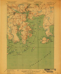
1918 Map of Machias
USGS Topo · Published 1918About this map
The coastal defenses and maritime economy of Washington County are clearly visible in this 1917 survey of the Down East shoreline. Historical landmarks like Fort O'Brien overlook the Machias River, while the Cross Island L S S stands watch over the complex archipelago and dangerous narrows at the entrance to Machias Bay. The landscape is a mix of tidal flats and granite rises, where small settlements like Machiasport and Dog Town are connected by the Maine Central Railroad.
Find a feature on this map
139 named features on this map. Tap any name to fly to it.
Don’t see what you’re looking for? This feature index may not catch every label — zoom into the map to look around manually.
Map Details
Editions of this 1918 Machias Map
5 editions found
Other maps of this area

1907 · Eastport
USGS Topo · 1:48,000

1908 · Eastport
USGS Topo · 1:62,500

1917 · Cutler
USGS Topo · 1:62,500

1918 · Machias
USGS Topo · 1:62,500

1918 · Cutler
USGS Topo · 1:62,500

1921 · Great Wass Island
USGS Topo · 1:62,500

1921 · Columbia Falls
USGS Topo · 1:62,500

1941 · Columbia Falls
USGS Topo · 1:62,500

1941 · Machias
USGS Topo · 1:62,500

1941 · Wesley
USGS Topo · 1:62,500