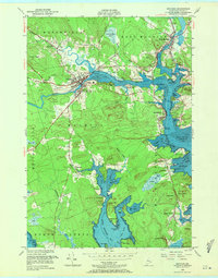
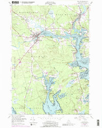
1949 Map of Machias
USGS Topo · Published 1971About this map
The confluence of the East Machias River and the Machias River defines the layout of this coastal Washington County region during the late 1940s. The town of Machias serves as a local hub, featuring the Washington State Normal School and the Longfellow Cem, while downstream the maritime character of the area is evident at Machiasport and Bucks Harbor. The landscape is a complex network of tidal inlets and coves, including Little Kennebec Bay and the extensive Randall Point Flats within Machias Bay. Historical coastal defenses and public lands are represented by Fort O'Brien Pt and Machias State Park. Smaller inland settlements like Kennebec, Hoyttown, and Marshfield are connected by a system of roads and a prominent Telephone Line that mirrors the early infrastructure of the Maine coast. Coastal navigation is guided by landmarks such as Libby Head, Yoho Head, and Crocker Point, providing a detailed view of the rugged Atlantic shoreline before modern development.
Find a feature on this map
79 named features on this map. Tap any name to fly to it.
Don’t see what you’re looking for? This feature index may not catch every label — zoom into the map to look around manually.
Map Details
Editions of this 1949 Machias Map
5 editions found
Other maps of this area

1918 · Machias
USGS Topo · 1:62,500

1921 · Columbia Falls
USGS Topo · 1:62,500

1941 · Columbia Falls
USGS Topo · 1:62,500

1941 · Machias
USGS Topo · 1:62,500

1941 · Wesley
USGS Topo · 1:62,500

1941 · Gardner Lake
USGS Topo · 1:62,500

1942 · Columbia Falls
USGS Topo · 1:62,500

1943 · Wesley
USGS Topo · 1:62,500

1943 · Gardner Lake
USGS Topo · 1:62,500

1948 · Jonesport
USGS Topo · 1:24,000