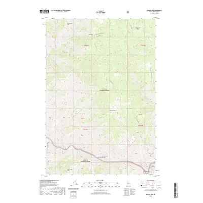
2020 Map of Mackay Bar
USGS Topo · Published 2020About this map
The Salmon River carves a deep path through Idaho's wilderness, marking the boundary between the Nez Perce National Forest and the Payette National Forest. This river corridor, designated as the Salmon Wild and Scenic River, serves as the primary artery for the region, with Deadman Rapids signaling the powerful hydraulics of the waterway. Small bars and flats along the river's edge, such as Indian Creek Bar and the namesake Mackay Bar, represent rare level ground in an otherwise vertical landscape. The presence of the Mackay Bar Airport highlights the remoteness of the terrain, where air travel often replaces traditional overland routes. High ridges and peaks like Drumlummen Ridge, Jersey Mtn, and Cove Mtn define the surrounding skyline, while the winding Mackay Bar Rd provides a precarious land connection through the mountain passes.
Find a feature on this map
41 named features on this map. Tap any name to fly to it.
Don’t see what you’re looking for? This feature index may not catch every label — zoom into the map to look around manually.
Map Details
Editions of this 2020 Mackay Bar Map
This is the sole edition of this map. No revisions or reprints were ever made.
Other maps of this area

1931 · Buffalo Hump
USGS Topo · 1:125,000

1934 · Buffalo Hump
USGS Topo · 1:125,000

1956 · Warren
USGS Topo · 1:62,500

1956 · Elk City
USGS Topo · 1:250,000

1960 · Elk City
USGS Topo · 1:250,000

1977 · Silver Spur Ridge
USGS Topo · 1:24,000

1978 · Chicken Peak
USGS Topo · 1:24,000

1979 · Buffalo Hump
USGS Topo · 1:24,000

1979 · Dixie
USGS Topo · 1:24,000

1979 · Fivemile Bar
USGS Topo · 1:24,000