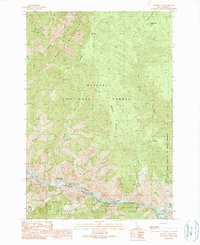
1989 Map of Mackay Bar
USGS Topo · Published 1989About this map
Salmon River canyon dominates this 1989 provisional survey, carving a deep boundary between the Nez Perce National Forest and the Payette National Forest. This remote corridor in Idaho County is characterized by isolated homesteads and mining claims that persisted long after the initial gold rushes. Isolated outposts such as Jersey Ranch, Indian Creek Ranch, and Romine Ranch are positioned along the river benches, accessible primarily by water or difficult mountain trails. The presence of the War Eagle Mine near Crooked Creek and additional unnamed Mines along the eastern ridges suggests the enduring legacy of mineral exploration in the Gospel-Hump Wilderness. Navigational hazards for river travelers are clearly marked, including the Warren Creek Rapids and Mann Creek Rapids, while the designation of the Salmon Wild and Scenic River reflects the late-century shift toward preservation of the Idaho backcountry.
Find a feature on this map
37 named features on this map. Tap any name to fly to it.
Don’t see what you’re looking for? This feature index may not catch every label — zoom into the map to look around manually.
Map Details
Editions of this 1989 Mackay Bar Map
This is the sole edition of this map. No revisions or reprints were ever made.
Other maps of this area

1931 · Buffalo Hump
USGS Topo · 1:125,000

1934 · Buffalo Hump
USGS Topo · 1:125,000

1956 · Warren
USGS Topo · 1:62,500

1956 · Elk City
USGS Topo · 1:250,000

1960 · Elk City
USGS Topo · 1:250,000

1977 · Silver Spur Ridge
USGS Topo · 1:24,000

1978 · Chicken Peak
USGS Topo · 1:24,000

1979 · Buffalo Hump
USGS Topo · 1:24,000

1979 · Dixie
USGS Topo · 1:24,000

1979 · Fivemile Bar
USGS Topo · 1:24,000