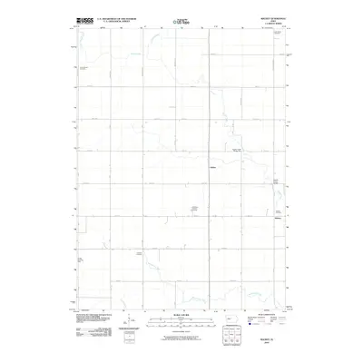
2010 Map of Mackey
USGS Topo · Published 2010About this map
Squaw Creek and its many tributaries, including Crooked Creek and Montgomery Creek, define the agricultural landscape of this northern Boone County region. The small settlement of Mackey anchors the eastern edge of the survey, situated near the Mackey Cemetery. The township's history is reflected in its numerous burial grounds, such as Saint Paul's Lutheran Cemetery and the Leininger Cemetery, which are scattered among the section lines and rural homesteads. The transport network is a rigid grid of gravel and paved roads, though specific crossings like Squaw Creek Bridge Two show where the natural hydrology forces breaks in the man-made symmetry. Further west, the map identifies the rural site of Griffen and the private Stotts Landing Field, illustrating the blend of traditional farming infrastructure and modern light aviation in the early 21st century.
Find a feature on this map
36 named features on this map. Tap any name to fly to it.
Don’t see what you’re looking for? This feature index may not catch every label — zoom into the map to look around manually.
Map Details
Editions of this 2010 Mackey Map
This is the sole edition of this map. No revisions or reprints were ever made.
Other maps of this area

1912 · Ames
USGS Topo · 1:62,500

1914 · Ames
USGS Topo · 1:62,500

1916 · Boone
USGS Topo · 1:62,500

1954 · Waterloo
USGS Topo · 1:250,000

1955 · Waterloo
USGS Topo · 1:250,000

1965 · Mackey
USGS Topo · 1:24,000

1965 · Fraser
USGS Topo · 1:24,000
1965 · Boone East
USGS Topo · 1:24,000
1965 · Boone West
USGS Topo · 1:24,000

1975 · Ames NW
USGS Topo · 1:24,000