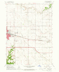
1965 Map of Boone East
USGS Topo · Published 1966About this map
The city of Boone serves as the focal point of this mid-1960s survey, showing a landscape defined by significant rail infrastructure and agricultural research. The intersection of the Chicago and North Western and the Fort Dodge Des Moines and Southern lines highlights the area's importance as a transportation hub. Beyond the city limits, the terrain transitions into the rolling drainage basins of Prairie Creek and North Onion Creek, where small landmarks like Prairie Center Ch and Lowell Sch anchor the rural community. To the south, the Iowa State University Agronomy Farm and Ledges State Park indicate a mix of academic influence and public conservation. Researchers will also find evidence of former transport routes along the Old Railroad Grade and local history at the Squire Boone Cem near the southern boundary.
Find a feature on this map
25 named features on this map. Tap any name to fly to it.
Don’t see what you’re looking for? This feature index may not catch every label — zoom into the map to look around manually.
Map Details
Editions of this 1965 Boone East Map
2 editions found
Other maps of this area

1911 · Madrid
USGS Topo · 1:62,500

1911 · Slater
USGS Topo · 1:62,500

1912 · Ames
USGS Topo · 1:62,500

1913 · Slater
USGS Topo · 1:62,500

1914 · Madrid
USGS Topo · 1:62,500

1914 · Ames
USGS Topo · 1:62,500

1916 · Boone
USGS Topo · 1:62,500

1954 · Waterloo
USGS Topo · 1:250,000

1954 · Des Moines
USGS Topo · 1:250,000

1955 · Waterloo
USGS Topo · 1:250,000