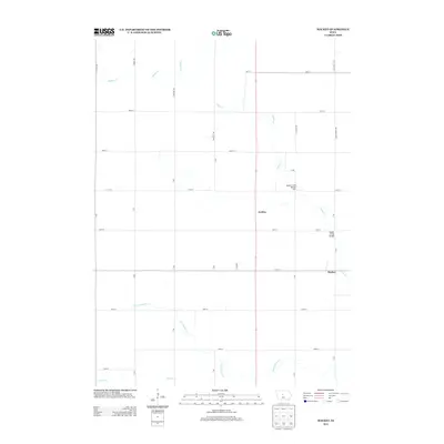
2013 Map of Mackey
USGS Topo · Published 2013About this map
The small settlement of Mackey sits at the intersection of 130th St and V Ave, anchoring a rural landscape defined by the winding path of Squaw Cr. In this early 21st-century survey of Boone County, the agricultural grid is etched with precision, punctuated by the northward community of Griffen. This area showcases a series of critical stream crossings, most notably the Squaw Creek Bridge and Squaw Creek Bridge Two, which facilitate travel across the local drainage network. Further south, the map details the headwaters and tributaries of Montgomery Cr and Prairie Cr as they cut through the farmland. The naming of thoroughfares like Inkpaduta Ave and Lakins Grove Ave provides a window into the historical naming conventions of the Iowa countryside, preserved even as modern infrastructure maintains the region's productive character.
Find a feature on this map
31 named features on this map. Tap any name to fly to it.
Don’t see what you’re looking for? This feature index may not catch every label — zoom into the map to look around manually.
Map Details
Editions of this 2013 Mackey Map
This is the sole edition of this map. No revisions or reprints were ever made.
Other maps of this area

1912 · Ames
USGS Topo · 1:62,500

1914 · Ames
USGS Topo · 1:62,500

1916 · Boone
USGS Topo · 1:62,500

1954 · Waterloo
USGS Topo · 1:250,000

1955 · Waterloo
USGS Topo · 1:250,000

1965 · Mackey
USGS Topo · 1:24,000

1965 · Fraser
USGS Topo · 1:24,000
1965 · Boone East
USGS Topo · 1:24,000
1965 · Boone West
USGS Topo · 1:24,000

1975 · Ames NW
USGS Topo · 1:24,000