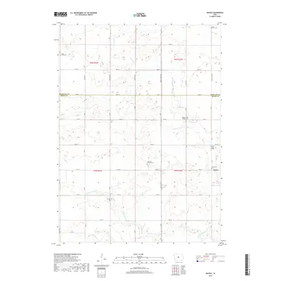
2018 Map of Mackey
USGS Topo · Published 2018About this map
Mackey sits at the intersection of V Ave and 130th St, serving as a focal point in this predominantly agricultural landscape on the border of Hamilton Co and Boone Co. The map documents a significant concentration of local heritage sites, particularly cemeteries that trace the settlement history of Dodge Township. From the South Marion Cem in the northwest to the Mackey Cem near the eastern border, these sites are often associated with early congregations, such as Saint Paul's Lutheran Cem. The terrain is defined by the winding paths of Squaw Cr and Montgomery Cr, which are crossed by local spans including Squaw Creek Bridge and Squaw Creek Bridge Two. A rigid grid of section roads like Inkpaduta Ave and Briggs Woods Rd organizes the prairie, reflecting the enduring legacy of the Public Land Survey System in central Iowa.
Find a feature on this map
41 named features on this map. Tap any name to fly to it.
Don’t see what you’re looking for? This feature index may not catch every label — zoom into the map to look around manually.
Map Details
Editions of this 2018 Mackey Map
This is the sole edition of this map. No revisions or reprints were ever made.
Other maps of this area

1912 · Ames
USGS Topo · 1:62,500

1914 · Ames
USGS Topo · 1:62,500

1916 · Boone
USGS Topo · 1:62,500

1954 · Waterloo
USGS Topo · 1:250,000

1955 · Waterloo
USGS Topo · 1:250,000

1965 · Mackey
USGS Topo · 1:24,000

1965 · Fraser
USGS Topo · 1:24,000
1965 · Boone East
USGS Topo · 1:24,000
1965 · Boone West
USGS Topo · 1:24,000

1975 · Ames NW
USGS Topo · 1:24,000