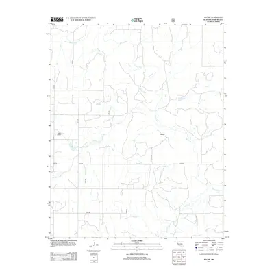
2012 Map of Mackie
USGS Topo · Published 2012About this map
Mackie serves as the namesake for this Western Oklahoma landscape, positioned within a network of section-line roads and winding watercourses. The drainage of the Washita River dominates the northern and eastern portions of the quadrangle, carving a serpentine path through the terrain. Joining the river from the west is Rush Cr, which features distinctive sandy deposits or alluvial patterns along its bank as it approaches the main river valley. To the southwest, Camp Hollow provides a named landmark amidst the draws and breaks that characterize this part of Roger Mills County. The south is defined by the headwaters and branches of Croton Cr, illustrating the transition between different drainage basins. This 2012 survey illustrates the modern rural infrastructure, where a grid of roads like n1790 RD and e0930 RD provides access to the agricultural lands surrounding the river systems.
Find a feature on this map
15 named features on this map. Tap any name to fly to it.
Don’t see what you’re looking for? This feature index may not catch every label — zoom into the map to look around manually.
Map Details
Editions of this 2012 Mackie Map
This is the sole edition of this map. No revisions or reprints were ever made.
Other maps of this area

1955 · Clinton
USGS Topo · 1:250,000

1957 · Clinton
USGS Topo · 1:250,000

1960 · Cheyenne
USGS Topo · 1:62,500

1961 · Reydon
USGS Topo · 1:62,500

1965 · Crawford
USGS Topo · 1:24,000

1966 · Roll
USGS Topo · 1:24,000

1966 · Durham
USGS Topo · 1:24,000

1984 · Foss Reservoir
USGS Topo · 1:100,000

1988 · Dempsey
USGS Topo · 1:24,000
1989 · Cheyenne NW
USGS Topo · 1:24,000