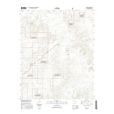
2016 Map of Mackie
USGS Topo · Published 2016About this map
The Black Kettle National Grassland dominates this portion of Roger Mills County, creating a fragmented mosaic of protected prairie and private agricultural land. The terrain is defined by the winding course of the Washita River and its various tributaries, including Rush Cr and Croton Cr. This landscape is heavily modified by mid-to-late 20th-century water management projects, evidenced by a dense network of flood control structures such as Upper Washita Site 63 Reservoir, Upper Washita Site 62 Reservoir, and Upper Washita Site 61 Reservoir. The small settlement of Mackie and the Sunrise Cem serve as focal points for local history and genealogy, situated among a grid of section-line roads. This map documents the persistent rural character of western Oklahoma, where the economy remains tied to ranching and watershed conservation.
Find a feature on this map
45 named features on this map. Tap any name to fly to it.
Don’t see what you’re looking for? This feature index may not catch every label — zoom into the map to look around manually.
Map Details
Editions of this 2016 Mackie Map
This is the sole edition of this map. No revisions or reprints were ever made.
Other maps of this area

1955 · Clinton
USGS Topo · 1:250,000

1957 · Clinton
USGS Topo · 1:250,000

1960 · Cheyenne
USGS Topo · 1:62,500

1961 · Reydon
USGS Topo · 1:62,500

1965 · Crawford
USGS Topo · 1:24,000

1966 · Roll
USGS Topo · 1:24,000

1966 · Durham
USGS Topo · 1:24,000

1984 · Foss Reservoir
USGS Topo · 1:100,000

1988 · Dempsey
USGS Topo · 1:24,000
1989 · Cheyenne NW
USGS Topo · 1:24,000