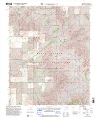
1998 Map of Mackie
USGS Topo · Published 2001About this map
Black Kettle National Grassland dominates this section of Roger Mills County, illustrating a landscape managed for conservation and energy production during the late 1990s. The Washita River meanders across the northern and eastern portions of the map, fed by tributaries such as Rush Creek and Croton Creek. This region is defined by its industrial layer, with dozens of active Gas Wells and Oil Wells scattered across the undulating terrain, particularly near the settlement of Mackie. The survey captures the complex land ownership patterns where public grassland inholdings coexist with private ranching and petroleum interests. Geographers and local historians can trace the network of pipelines and service roads that crisscross the drainage basins of Camp Hollow, reflecting the vital intersection of Great Plains ecology and the mid-continent oil boom.
Find a feature on this map
9 named features on this map. Tap any name to fly to it.
Don’t see what you’re looking for? This feature index may not catch every label — zoom into the map to look around manually.
Map Details
Editions of this 1998 Mackie Map
This is the sole edition of this map. No revisions or reprints were ever made.
Other maps of this area

1955 · Clinton
USGS Topo · 1:250,000

1957 · Clinton
USGS Topo · 1:250,000

1960 · Cheyenne
USGS Topo · 1:62,500

1961 · Reydon
USGS Topo · 1:62,500

1965 · Crawford
USGS Topo · 1:24,000

1966 · Roll
USGS Topo · 1:24,000

1966 · Durham
USGS Topo · 1:24,000

1984 · Foss Reservoir
USGS Topo · 1:100,000

1988 · Dempsey
USGS Topo · 1:24,000
1989 · Cheyenne NW
USGS Topo · 1:24,000