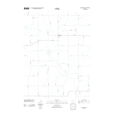
2013 Map of Macksburg
USGS Topo · Published 2013About this map
The town of Macksburg sits as the central hub of this Madison County landscape, where the local grid of streets like W N St and Oak Ave meets the rural agricultural sections. The area is defined by a dense network of waterways including the Thompson River, N Fork Clanton Cr, and Rocky Br, which carve through the Iowa countryside. This 2013 survey illustrates the modern persistence of the rectangular land survey system, with named thoroughfares such as Macksburg Rd and Co Hwy-G61 providing primary transit between farmsteads. The drainage pattern is particularly intricate here, with numerous small tributaries like Loeffler Cr and Fletcher Br feeding into the larger river systems, dictating the placement of secondary roads and field boundaries.
Find a feature on this map
58 named features on this map. Tap any name to fly to it.
Don’t see what you’re looking for? This feature index may not catch every label — zoom into the map to look around manually.
Map Details
Editions of this 2013 Macksburg Map
This is the sole edition of this map. No revisions or reprints were ever made.
Other maps of this area

1951 · Afton
USGS Topo · 1:62,500

1952 · Winterset
USGS Topo · 1:62,500

1954 · Greenfield
USGS Topo · 1:62,500

1954 · Omaha
USGS Topo · 1:250,000

1957 · Omaha
USGS Topo · 1:250,000

1958 · Omaha
USGS Topo · 1:250,000

1980 · Creston East
USGS Topo · 1:24,000

1981 · Zion
USGS Topo · 1:24,000
1983 · Afton
USGS Topo · 1:24,000
1983 · Lorimor South
USGS Topo · 1:24,000