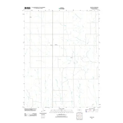
2011 Map of Macon
USGS Topo · Published 2011About this map
The settlement of Macon serves as the central point in this Franklin County landscape, defined by a network of north-south drainage and early 21st-century agricultural infrastructure. The terrain is etched by numerous watercourses including Walnut Run, Wasp Creek, and Coates Creek, which flow through a grid of local roads and sections. Evidence of modern land management is visible through features like the Bauman Dam-1 Dam and Lemmert Dam, which manage the local watershed. To the northwest, the Blauvelt Cemetery stands as a significant point for genealogical research, anchoring the map's history to the families who settled this part of Nebraska. The eastern boundary is defined by the winding course of West Branch Thompson Creek, illustrating the natural irrigation patterns that support the region's rural character.
Find a feature on this map
12 named features on this map. Tap any name to fly to it.
Don’t see what you’re looking for? This feature index may not catch every label — zoom into the map to look around manually.
Map Details
Editions of this 2011 Macon Map
This is the sole edition of this map. No revisions or reprints were ever made.
Other maps of this area

1896 · Holdrege
USGS Topo · 1:125,000

1897 · Red Cloud
USGS Topo · 1:125,000

1955 · Grand Island
USGS Topo · 1:250,000

1957 · Grand Island
USGS Topo · 1:250,000

1958 · Grand Island
USGS Topo · 1:250,000

1969 · Upland
USGS Topo · 1:24,000

1969 · Upland SE
USGS Topo · 1:24,000
1970 · Hildreth
USGS Topo · 1:24,000
1973 · Macon
USGS Topo · 1:24,000
1973 · Republican City NE
USGS Topo · 1:24,000