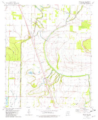
1981 Map of Macon Lake
USGS Topo · Published 1982About this map
Macon Lake and the serpentine course of Macon Bayou dominate this Chicot County landscape, reflecting the intricate drainage patterns of the Mississippi Delta. The map documents an area defined by its water management and agricultural infrastructure, featuring an extensive network of artificial waterways like the Boeuf River Diversion Canal, Bayou Canal, and Clay Bayou Canal. Small rural settlements such as Norcross, Elmwood, and Bowman are scattered throughout the quadrangle, connected by the Missouri Pacific railroad line which cuts a straight path through the bottomlands. Religious and community life is anchored by local landmarks including Holly Grove Ch and Strangers Rest Ch, while the presence of a Fish Farm and a Fish Hatchery indicates the importance of aquaculture in the local economy during the early 1980s.
Find a feature on this map
30 named features on this map. Tap any name to fly to it.
Don’t see what you’re looking for? This feature index may not catch every label — zoom into the map to look around manually.
Map Details
Editions of this 1981 Macon Lake Map
This is the sole edition of this map. No revisions or reprints were ever made.
Other maps of this area

1933 · Lamont
USGS Topo · 1:62,500

1936 · McGehee
USGS Topo · 1:62,500

1936 · Lake Village
USGS Topo · 1:62,500

1937 · McGehee
USGS Topo · 1:62,500

1939 · Refuge
USGS Topo · 1:62,500

1939 · Lamont
USGS Topo · 1:62,500

1953 · Greenwood
USGS Topo · 1:250,000

1955 · Lake Village
USGS Topo · 1:62,500

1955 · McGehee
USGS Topo · 1:62,500

1956 · Greenwood
USGS Topo · 1:250,000