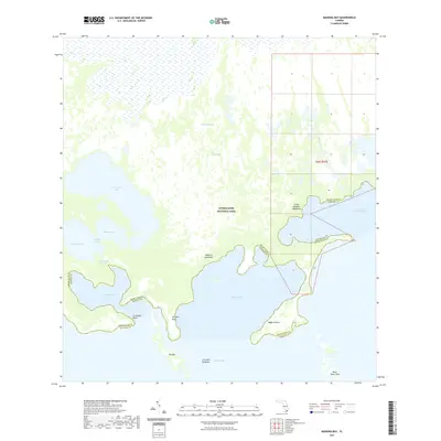
2021 Map of Madeira Bay
USGS Topo · Published 2021About this map
Everglades National Park covers the vast majority of this coastal landscape, where the freshwater drainage of the Taylor Slough and Taylor River meets the saltwater of the Florida coast. This transitional environment is defined by a complex network of internal lakes such as Seven Palm Lake, Middle Lake, and Monroe Lake, which feed into the tidal waters of Terrapin Bay and Madeira Bay. The map illustrates the jagged boundary between Miami-Dade and Monroe Counties, snaking through the mangrove-fringed shoreline and open waters of Florida Bay. Terrestrial features are limited to significant coastal rises and islands, including Maderia Hammock, Little Madeira Hammock, and Big Key. Landmarks like Crocodile Point and Crocodile Dragover suggest the specific wildlife habitat central to this protected wilderness area.
Find a feature on this map
23 named features on this map. Tap any name to fly to it.
Don’t see what you’re looking for? This feature index may not catch every label — zoom into the map to look around manually.
Map Details
Editions of this 2021 Madeira Bay Map
This is the sole edition of this map. No revisions or reprints were ever made.
Other maps of this area

1956 · Royal Palm Ranger Station SE
USGS Topo · 1:24,000

1956 · Miami
USGS Topo · 1:250,000

1958 · Miami
USGS Topo · 1:250,000

1967 · Royal Palm Ranger Station SE
USGS Topo · 1:24,000

1971 · Tavernier
USGS Topo · 1:24,000

1972 · Mahogany Hammock
USGS Topo · 1:24,000

1972 · Taylor Slough
USGS Topo · 1:24,000

1972 · Madeira Bay
USGS Topo · 1:24,000

1972 · Pelican Keys
USGS Topo · 1:24,000

1972 · West Lake
USGS Topo · 1:24,000