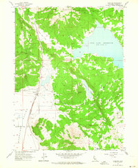
1962 Map of Madeline
USGS Topo · Published 1964About this map
Madeline sits at the junction of the Southern Pacific railroad and the Ash Valley Road in this 1962 field-checked study of the High Desert. The settlement serves as a focal point for the surrounding Madeline Plains, a landscape defined by ranching infrastructure such as the Water Tanks and a Gravel Pit. The rugged geography is dominated by Tule Mountain and Tule Lake Reservoir, illustrating the critical role of water management in this arid region of Lassen County. Smaller landmarks like Pinnio and the Mendiboure Reservoir further detail the local cattle and irrigation history, while family-named features like Cochran Hill and Olson Mtn offer specific points of interest for genealogists tracing early residents of the northern plains. The map also captures the path of Van Loan Creek as it flows toward the south, providing a record of the area's natural drainage before modern developments.
Find a feature on this map
21 named features on this map. Tap any name to fly to it.
Don’t see what you’re looking for? This feature index may not catch every label — zoom into the map to look around manually.
Map Details
Editions of this 1962 Madeline Map
2 editions found
Other maps of this area

1886 · Alturas
USGS Topo · 1:250,000

1886 · Honey Lake
USGS Topo · 1:250,000

1891 · Honey Lake
USGS Topo · 1:250,000

1892 · Alturas
USGS Topo · 1:250,000

1893 · Honey Lake
USGS Topo · 1:250,000

1954 · Grasshopper Valley
USGS Topo · 1:62,500

1954 · Ravendale
USGS Topo · 1:62,500

1954 · Alturas
USGS Topo · 1:250,000

1955 · Westwood
USGS Topo · 1:250,000

1958 · Alturas
USGS Topo · 1:250,000