1962 Map of Madeline
USGS Topo · Published 1977About this map
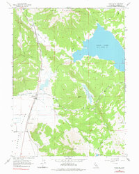
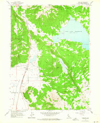
Madeline sits at the western edge of the expansive Madeline Plains, serving as a focal point for the ranching and transport network of northeastern Lassen County in the mid-1970s. The Southern Pacific railroad corridor defines the valley floor, connecting the small settlements of Sage Hen and Pinnio while passing by industrial markers like the Gravel Pit. The map captures a high-desert landscape transition from the level basin to the peaks of Tule Mountain and Olson Mtn. Water management is central to this environment, evidenced by the large expanse of Moon Lake and smaller features like Mendiboure Reservoir and the drainage of Van Loan Creek. Numerous jeep trails and named routes such as Ash Valley Road and Clarks Valley Road branch out from the rail line to provide access to the surrounding flats and timbered hills.
Find a feature on this map
23 named features on this map. Tap any name to fly to it.
Don’t see what you’re looking for? This feature index may not catch every label — zoom into the map to look around manually.
Map Details
Editions of this 1962 Madeline Map
2 editions found
Other maps of this area

1886 · Alturas
USGS Topo · 1:250,000

1886 · Honey Lake
USGS Topo · 1:250,000

1891 · Honey Lake
USGS Topo · 1:250,000

1892 · Alturas
USGS Topo · 1:250,000

1893 · Honey Lake
USGS Topo · 1:250,000
1954 · Grasshopper Valley
USGS Topo · 1:62,500
1954 · Ravendale
USGS Topo · 1:62,500

1954 · Alturas
USGS Topo · 1:250,000

1955 · Westwood
USGS Topo · 1:250,000

1958 · Alturas
USGS Topo · 1:250,000