
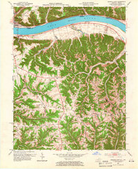
1953 Map of Madison East
USGS Topo · Published 1955About this map
The Ohio River carves a wide path through this mid-century landscape, separating the established settlement of Madison from the hills and valleys of Kentucky. On the southern bank, Milton serves as a key crossing point, with Telegraph Road and various ridges like Fairview Ridge and Leeport Ridge defining the local geography. The map reveals a deeply dissected upland where numerous small communities and family farms are anchored by local institutions such as Mt Carmel Ch, Hopewell Ch, and Mt Tabor Ch.
Find a feature on this map
44 named features on this map. Tap any name to fly to it.
Don’t see what you’re looking for? This feature index may not catch every label — zoom into the map to look around manually.
Map Details
Editions of this 1953 Madison East Map
2 editions found
Other maps of this area

1939 · Bethlehem
USGS Topo · 1:24,000

1939 · Madison West
USGS Topo · 1:24,000

1943 · Brooksburg
USGS Topo · 1:24,000

1948 · Bethlehem
USGS Topo · 1:24,000

1948 · Madison West
USGS Topo · 1:24,000

1952 · Campbellsburg
USGS Topo · 1:24,000

1953 · Madison West
USGS Topo · 1:24,000

1953 · Bedford
USGS Topo · 1:24,000

1953 · Carrollton
USGS Topo · 1:24,000

1953 · Bethlehem
USGS Topo · 1:24,000