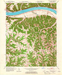
1953 Map of Madison East
USGS Topo · Published 1966About this map
The Ohio River carves a deep valley between Indiana and Kentucky on this mid-century survey, defining the economic and social geography of Madison and Milton. In the southern Kentucky hills, a network of ridges—including Fairview Ridge, Kings Ridge, and New Hope Ridge—dictates the placement of rural homesteads and social centers. These elevated plateaus are dotted with numerous small churches and schools that served the agricultural community, such as Mt Carmel Ch, Hopewell Ch, and Locust Sch. Along the river bottomlands, the settlement of Hunters Bottom shows a different pattern of land use, where flatter terrain allowed for more concentrated development near the water. The presence of the Callis Grove Campground and various family-named landmarks like Canip Creek and Pryors Fork provide specific points of interest for genealogists tracing family roots in Jefferson, Carroll, and Trimble counties.
Find a feature on this map
50 named features on this map. Tap any name to fly to it.
Don’t see what you’re looking for? This feature index may not catch every label — zoom into the map to look around manually.
Map Details
Editions of this 1953 Madison East Map
2 editions found
Other maps of this area

1939 · Bethlehem
USGS Topo · 1:24,000

1939 · Madison West
USGS Topo · 1:24,000

1943 · Brooksburg
USGS Topo · 1:24,000

1948 · Bethlehem
USGS Topo · 1:24,000

1948 · Madison West
USGS Topo · 1:24,000

1952 · Campbellsburg
USGS Topo · 1:24,000

1953 · Madison West
USGS Topo · 1:24,000

1953 · Bedford
USGS Topo · 1:24,000

1953 · Carrollton
USGS Topo · 1:24,000

1953 · Madison East
USGS Topo · 1:24,000