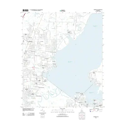
2012 Map of Madison
USGS Topo · Published 2012About this map
Madison and its surrounding suburban developments dominate this early 21st-century landscape along the Natchez Trace Pkwy. The area is characterized by a dense network of residential communities, including Stonegate, Traceland North, and Village Square, which reflect the significant northward expansion of the Jackson metropolitan region. This growth is juxtaposed with the sprawling waters of the Ross R Barnett Reservoir, which shapes the eastern geography and supports recreational hubs like Woodlake and Harbourview.
Find a feature on this map
54 named features on this map. Tap any name to fly to it.
Don’t see what you’re looking for? This feature index may not catch every label — zoom into the map to look around manually.
Map Details
Editions of this 2012 Madison Map
This is the sole edition of this map. No revisions or reprints were ever made.
Other maps of this area

1903 · Jackson
USGS Topo · 1:125,000

1905 · Jackson
USGS Topo · 1:48,000

1908 · Jackson
USGS Topo · 1:62,500

1922 · Pelahatchee
USGS Topo · 1:48,000

1924 · Pelahatchee
USGS Topo · 1:62,500

1950 · Pelahatchie
USGS Topo · 1:62,500

1952 · Pelahatchie
USGS Topo · 1:62,500

1953 · Meridian
USGS Topo · 1:250,000

1955 · Jackson
USGS Topo · 1:250,000

1957 · Meridian
USGS Topo · 1:250,000