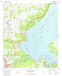
1980 Map of Madison
USGS Topo · Published 1980About this map
The Ross Barnett Reservoir dominates the landscape on the northeastern edge of Jackson, marking a period of significant suburban growth and infrastructure development. The Pearl River channel winds through the reservoir's expansive waters, which are flanked by recreation spots like the Lakeshore Recreation Area and Lakeview Marina. To the northwest, the town of Madison is shown during its transition from a quiet railroad stop to a more developed residential hub.
Find a feature on this map
45 named features on this map. Tap any name to fly to it.
Don’t see what you’re looking for? This feature index may not catch every label — zoom into the map to look around manually.
Map Details
Editions of this 1980 Madison Map
This is the sole edition of this map. No revisions or reprints were ever made.
Other maps of this area

1903 · Jackson
USGS Topo · 1:125,000

1905 · Jackson
USGS Topo · 1:48,000

1908 · Jackson
USGS Topo · 1:62,500

1922 · Pelahatchee
USGS Topo · 1:48,000

1924 · Pelahatchee
USGS Topo · 1:62,500

1950 · Pelahatchie
USGS Topo · 1:62,500

1952 · Pelahatchie
USGS Topo · 1:62,500

1953 · Meridian
USGS Topo · 1:250,000

1955 · Jackson
USGS Topo · 1:250,000

1957 · Meridian
USGS Topo · 1:250,000