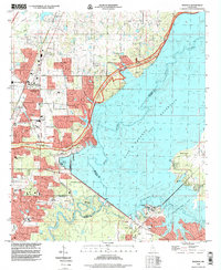
1998 Map of Madison
USGS Topo · Published 1998About this map
The northern suburbs of Jackson and the rapidly expanding city of Madison dominate this landscape during the late 1990s. This survey illustrates a period of significant suburban development at the tri-county junction of Madison, Hinds, and Rankin counties. The massive Ross Barnett Reservoir anchors the eastern half of the map, creating a complex shoreline that defines the Pelahatchie Recreation Area and Lakeshore Park.
Find a feature on this map
50 named features on this map. Tap any name to fly to it.
Don’t see what you’re looking for? This feature index may not catch every label — zoom into the map to look around manually.
Map Details
Editions of this 1998 Madison Map
This is the sole edition of this map. No revisions or reprints were ever made.
Other maps of this area

1903 · Jackson
USGS Topo · 1:125,000

1905 · Jackson
USGS Topo · 1:48,000

1908 · Jackson
USGS Topo · 1:62,500

1922 · Pelahatchee
USGS Topo · 1:48,000

1924 · Pelahatchee
USGS Topo · 1:62,500

1950 · Pelahatchie
USGS Topo · 1:62,500

1952 · Pelahatchie
USGS Topo · 1:62,500

1953 · Meridian
USGS Topo · 1:250,000

1955 · Jackson
USGS Topo · 1:250,000

1957 · Meridian
USGS Topo · 1:250,000