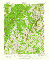
1930 Map of Madison
USGS Topo · Published 1961About this map
Stanardsville and the surrounding Blue Ridge foothills are captured here during a period of transition as the federal government was establishing parklands in the late 1920s. A notable site of the era is The Presidents Camp on the Mill Prong, established for Herbert Hoover near the headwaters of the Rapidan River. The map shows a landscape defined by small mountain settlements like Criglersville, Graves Mill, and Syria, alongside numerous community hubs such as Mt Olivet Ch and Hales Store.
Find a feature on this map
113 named features on this map. Tap any name to fly to it.
Don’t see what you’re looking for? This feature index may not catch every label — zoom into the map to look around manually.
Map Details
Editions of this 1930 Madison Map
3 editions found
Other maps of this area

1892 · Woodstock
USGS Topo · 1:125,000

1892 · Gordonsville
USGS Topo · 1:125,000

1892 · Harrisonburg
USGS Topo · 1:125,000

1893 · Luray
USGS Topo · 1:125,000

1905 · Luray
USGS Topo · 1:125,000

1929 · Stony Man
USGS Topo · 1:48,000

1930 · Madison
USGS Topo · 1:48,000

1931 · University
USGS Topo · 1:62,500

1933 · Stony Man
USGS Topo · 1:62,500

1933 · Madison
USGS Topo · 1:62,500