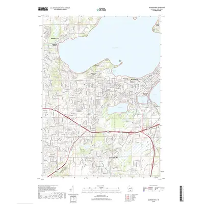
2018 Map of Madison West
USGS Topo · Published 2018About this map
Lake Mendota dominates the northern half of this landscape, its shoreline defined by the prominent Picnic Point and Eagle Heights. The capital city's development is evident in the dense street grids of Madison and the sprawling campus of the University of Wisconsin-Madison, extending toward the heights of Bascom Hill and Mansion Hill. This modern survey illustrates the extensive green spaces preserved within the urban fabric, most notably the large Arboretum surrounding Lake Wingra. A cluster of historic burial grounds, including the Forest Hill Cem Soldiers Lot and Resurrection Cem, provides a significant record of the community's heritage. To the south, the city of Fitchburg shows a transition toward more open terrain, while the Isthmus area connects the major water bodies via Wingra Creek.
Find a feature on this map
53 named features on this map. Tap any name to fly to it.
Don’t see what you’re looking for? This feature index may not catch every label — zoom into the map to look around manually.
Map Details
Editions of this 2018 Madison West Map
This is the sole edition of this map. No revisions or reprints were ever made.
Other maps of this area

1889 · Evansville
USGS Topo · 1:62,500

1890 · Madison
USGS Topo · 1:62,500

1892 · Madison
USGS Topo · 1:62,500

1894 · Evansville
USGS Topo · 1:62,500

1904 · Madison
USGS Topo · 1:62,500

1906 · Evansville
USGS Topo · 1:62,500

1906 · Madison
USGS Topo · 1:62,500

1907 · Cross Plains
USGS Topo · 1:62,500

1909 · Cross Plains
USGS Topo · 1:62,500

1923 · New Glarus
USGS Topo · 1:62,500