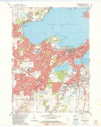
1983 Map of Madison West
USGS Topo · Published 1984About this map
The University of Wisconsin campus dominates the central isthmus of this 1980s landscape, serving as a focal point between the expansive Lake Mendota and Lake Monona. This survey captures the capital city during a period of significant suburban expansion, where established neighborhoods in Shorewood Hills and Middleton meet the burgeoning residential developments of Madison Township. The proximity of the State Capitol to the lakeside preserves the city's iconic skyline, while the vast Arboretum and Lake Wingra maintain a large corridor of green space amidst the urban grid.
Find a feature on this map
156 named features on this map. Tap any name to fly to it.
Don’t see what you’re looking for? This feature index may not catch every label — zoom into the map to look around manually.
Map Details
Editions of this 1983 Madison West Map
This is the sole edition of this map. No revisions or reprints were ever made.
Other maps of this area

1889 · Evansville
USGS Topo · 1:62,500

1890 · Madison
USGS Topo · 1:62,500

1892 · Madison
USGS Topo · 1:62,500

1894 · Evansville
USGS Topo · 1:62,500

1904 · Madison
USGS Topo · 1:62,500

1906 · Evansville
USGS Topo · 1:62,500

1906 · Madison
USGS Topo · 1:62,500

1907 · Cross Plains
USGS Topo · 1:62,500

1909 · Cross Plains
USGS Topo · 1:62,500

1923 · New Glarus
USGS Topo · 1:62,500