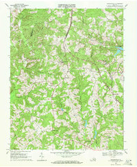
1968 Map of Madisonville
USGS Topo · Published 1972About this map
Madisonville serves as the central hub of this late 1960s landscape, situated at the crossroads of Virginia's Piedmont where Prince Edward, Appomattox, and Charlotte Counties converge. The map documents a predominantly rural and agricultural layout defined by an extensive network of country houses and community centers, including Alabama Ch, Salem Ch, and White Oak Grove Ch. Evidence of local industry and transport is clear, from the Norfolk and Western rail line serving Maloney Siding to the presence of a Mine and an Industrial Waste Pond near Spring Creek.
Find a feature on this map
40 named features on this map. Tap any name to fly to it.
Don’t see what you’re looking for? This feature index may not catch every label — zoom into the map to look around manually.
Map Details
Editions of this 1968 Madisonville Map
2 editions found
Other maps of this area

1892 · Appomattox
USGS Topo · 1:125,000

1947 · Roanoke
USGS Topo · 1:250,000

1956 · Brookneal
USGS Topo · 1:62,500

1956 · Charlotte Court House
USGS Topo · 1:62,500

1958 · Appomattox
USGS Topo · 1:62,500

1958 · Pamplin City
USGS Topo · 1:62,500

1959 · Roanoke
USGS Topo · 1:250,000

1963 · Roanoke
USGS Topo · 1:250,000
1967 · Prospect
USGS Topo · 1:24,000
1968 · Red House
USGS Topo · 1:24,000