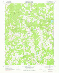
1968 Map of Madisonville
USGS Topo · Published 1977About this map
Madisonville serves as the central hub of this Piedmont landscape, situated where the Norfolk and Western railway cuts through the hills of Charlotte County. The terrain is defined by a dense network of drainages, including the prominent Wards Fork Creek and its tributary Terrys Creek, which flow southward through deeply carved valleys. Landmarks such as Lyle Mtn and Baker Mtn rise above the agricultural and timbered lands, with the latter featuring a noted Mine.
Find a feature on this map
38 named features on this map. Tap any name to fly to it.
Don’t see what you’re looking for? This feature index may not catch every label — zoom into the map to look around manually.
Map Details
Editions of this 1968 Madisonville Map
2 editions found
Other maps of this area

1892 · Appomattox
USGS Topo · 1:125,000

1947 · Roanoke
USGS Topo · 1:250,000

1956 · Brookneal
USGS Topo · 1:62,500

1956 · Charlotte Court House
USGS Topo · 1:62,500

1958 · Appomattox
USGS Topo · 1:62,500

1958 · Pamplin City
USGS Topo · 1:62,500

1959 · Roanoke
USGS Topo · 1:250,000

1963 · Roanoke
USGS Topo · 1:250,000
1967 · Prospect
USGS Topo · 1:24,000
1968 · Red House
USGS Topo · 1:24,000