
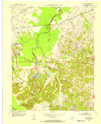
1953 Map of Madisonville East
USGS Topo · Published 1954About this map
Madisonville serves as the primary urban hub on this mid-century survey, shown alongside several satellite coal-country settlements like Barnsley and Earlington. The landscape is heavily defined by the extraction economy of the era, with numerous Strip Mines and industrial infrastructure such as the Central Transformer Sta and Waterworks dotting the terrain. The presence of the Kentucky Tuberculosis Hospital and various specialized schools like Waddill Sch and High Sch reflect the town's role as a regional center for healthcare and education.
Find a feature on this map
43 named features on this map. Tap any name to fly to it.
Don’t see what you’re looking for? This feature index may not catch every label — zoom into the map to look around manually.
Map Details
Editions of this 1953 Madisonville East Map
This is the sole edition of this map. No revisions or reprints were ever made.
Other maps of this area

1907 · Earlington
USGS Topo · 1:48,000

1909 · Dawson Springs
USGS Topo · 1:48,000

1909 · Earlington
USGS Topo · 1:62,500

1909 · Madisonville
USGS Topo · 1:62,500

1911 · Dawson Springs
USGS Topo · 1:62,500

1912 · Nortonville
USGS Topo · 1:62,500

1952 · Sacramento
USGS Topo · 1:24,000

1952 · Hanson
USGS Topo · 1:24,000

1953 · Nortonville
USGS Topo · 1:24,000
1953 · Millport
USGS Topo · 1:24,000