1983 Map of Madisonville
USGS Topo · Published 1984About this map
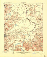
Pennyrile State Forest and the Jones-Keeney Wildlife Management Area dominate the wooded southwestern corner of this Western Kentucky landscape. This 1983 revision reveals a region defined by its complex drainage basins, where the Tradewater River and Pond River snake through a patchwork of timber and open terrain. The mapping shows the industrial and transit importance of the Seaboard System and Illinois Central Gulf railroads, which link the coal-rich corridor from Madisonville through Central City and Greenville.
Find a feature on this map
119 named features on this map. Tap any name to fly to it.
Don’t see what you’re looking for? This feature index may not catch every label — zoom into the map to look around manually.
Map Details
Editions of this 1983 Madisonville Map
This is the sole edition of this map. No revisions or reprints were ever made.