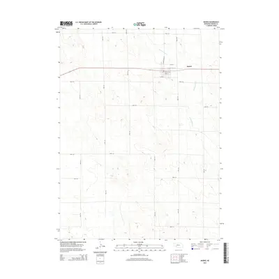
2014 Map of Madrid
USGS Topo · Published 2014About this map
Madrid serves as the primary hub in this portion of Perkins County, centered around a compact street grid that includes Stone St, Longfellow St, and Lowell St. The settlement is supported by a Po and is positioned along a primary east-west corridor. Outside of the town center, the landscape is defined by the winding course of Stinking Water Cr, which cuts through the high plains terrain. This drainage system provides a stark contrast to the rigid, mile-block geometry of the surrounding rural road network, which includes arterial routes like Madrid Roscoe Rd and numerous numbered section-line roads. The map illustrates a classic High Plains agricultural layout where nearly every square mile is accessible by a planned thoroughfare, such as Road 762 or Road 335.
Find a feature on this map
20 named features on this map. Tap any name to fly to it.
Don’t see what you’re looking for? This feature index may not catch every label — zoom into the map to look around manually.
Map Details
Editions of this 2014 Madrid Map
This is the sole edition of this map. No revisions or reprints were ever made.
Other maps of this area

1954 · McCook
USGS Topo · 1:250,000

1957 · McCook
USGS Topo · 1:250,000

1958 · McCook
USGS Topo · 1:250,000
1973 · Grant NE
USGS Topo · 1:24,000

1973 · Imperial NE
USGS Topo · 1:24,000
1973 · Elsie NW
USGS Topo · 1:24,000

1973 · Dittons Creek NW
USGS Topo · 1:24,000
1973 · Grant
USGS Topo · 1:24,000
1973 · Imperial NW
USGS Topo · 1:24,000
1973 · Elsie
USGS Topo · 1:24,000