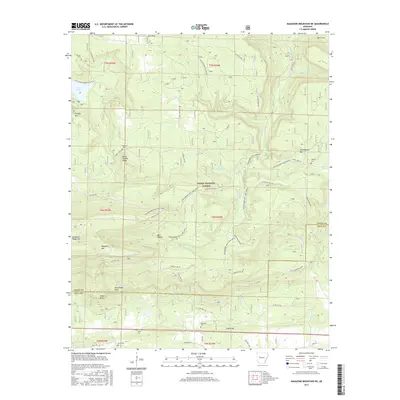
2017 Map of Magazine Mountain NE
USGS Topo · Published 2017About this map
Ozark National Forest covers much of this high-relief landscape along the border of Logan and Yell Counties. The map captures a topography defined by steep ridges and deep hollows, including the prominent peaks of Magazine Mtn and Huckleberry Mtn. This area is crisscrossed by an extensive network of specialized trails and byways, such as the Huckleberry Mtn Horse Trail and the Rich Mountain Road Byway, reflecting the region's importance for timber management and recreational access. Small, isolated burial grounds like Antioch Cem, Liberty Cem, and Valentine Cem are tucked into the drainages of Cove Cr and Little Piney Cr, marking the locations of earlier homesteads and rural communities that once farmed these valleys before the federal forest's consolidation.
Find a feature on this map
57 named features on this map. Tap any name to fly to it.
Don’t see what you’re looking for? This feature index may not catch every label — zoom into the map to look around manually.
Map Details
Editions of this 2017 Magazine Mountain NE Map
This is the sole edition of this map. No revisions or reprints were ever made.
Other maps of this area

1879 · Mountain Home
USGS Topo · 1:62,500

1887 · Magazine Mountain #1
USGS Topo · 1:62,500

1887 · Magazine Mountain #4
USGS Topo · 1:62,500

1887 · Magazine Mountain
USGS Topo · 1:62,500

1888 · Dardanelle #2
USGS Topo · 1:62,500

1888 · Dardanelle #3
USGS Topo · 1:62,500

1890 · Magazine Mountain
USGS Topo · 1:125,000

1890 · Dardanelle
USGS Topo · 1:125,000

1956 · Russellville
USGS Topo · 1:250,000
1961 · Scranton
USGS Topo · 1:24,000