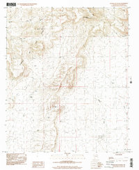
1996 Map of Magdalena Peak
USGS Topo · Published 2001About this map
Magdalena Peak serves as the focal point for this arid landscape in Doña Ana County, where an Observatory sits atop the high ground overlooking the Sierra de las Uvas. The terrain is defined by a sophisticated system of water catchment tanks, essential for ranching and survival in this desert environment. These features, including Lone Tree Tank, Talanio Pinto Tank, and Little Mills Tank, are distributed across the foothills and canyon floors. Natural drainage patterns are clearly marked by the deep incisions of Mason Draw and Silva Canyon. To the north, the elevation levels out toward Flat Top and Mesa Azul, while the central portion of the map is dominated by the complex ridges of Mountain and The Saddle. This survey reflects the late 20th-century geographic state of these high-desert uplands prior to significant modern development.
Find a feature on this map
23 named features on this map. Tap any name to fly to it.
Don’t see what you’re looking for? This feature index may not catch every label — zoom into the map to look around manually.
Map Details
Editions of this 1996 Magdalena Peak Map
This is the sole edition of this map. No revisions or reprints were ever made.
Other maps of this area

1943 · Corralitos Ranch
USGS Topo · 1:62,500

1955 · Las Cruces
USGS Topo · 1:250,000

1958 · Las Cruces
USGS Topo · 1:250,000
1959 · Sierra Alta
USGS Topo · 1:24,000
1959 · Souse Springs
USGS Topo · 1:24,000

1961 · Nutt
USGS Topo · 1:62,500

1972 · Good Sight Peak NE
USGS Topo · 1:24,000

1972 · Lazy E Ranch
USGS Topo · 1:24,000

1982 · Hatch
USGS Topo · 1:100,000
1982 · Deming
USGS Topo · 1:100,000