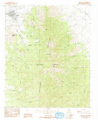
1985 Map of Magdalena
USGS Topo · Published 1985About this map
Magdalena sits at the northern edge of the high mountain terrain, serving as a gateway to the steep ridges and deep drainages of the Cibola National Forest. The landscape is dominated by the massive profile of the Magdalena Mountains, where summits like North Baldy and Magdalena Peak rise above a complex network of canyons. The map records the area's industrial footprint through the presence of Tailings and an Old Railroad Grade, which speaks to the historical mining activity that once thrived in the vicinity of Kelly Gulch.
Find a feature on this map
29 named features on this map. Tap any name to fly to it.
Don’t see what you’re looking for? This feature index may not catch every label — zoom into the map to look around manually.
Map Details
Editions of this 1985 Magdalena Map
This is the sole edition of this map. No revisions or reprints were ever made.
Other maps of this area

1954 · Tularosa
USGS Topo · 1:250,000

1954 · Socorro
USGS Topo · 1:250,000

1958 · Socorro
USGS Topo · 1:250,000

1958 · Tularosa
USGS Topo · 1:250,000

1959 · Magdalena
USGS Topo · 1:62,500

1962 · Socorro
USGS Topo · 1:250,000

1963 · Arroyo Landavaso
USGS Topo · 1:24,000

1964 · Silver Hill
USGS Topo · 1:24,000
1965 · Squaw Peak
USGS Topo · 1:24,000
1965 · South Baldy
USGS Topo · 1:24,000