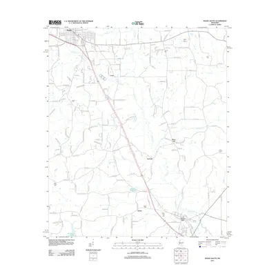
2012 Map of Magee South
USGS Topo · Published 2012About this map
Merry Hell and Saratoga sit along the central transportation corridor of this Simpson County region, where rail and road infrastructure follow the natural drainage of Okatoma Cr. The landscape transitions from the southern edge of Magee toward Mount Olive, defined by a network of creek systems including Goodwater Cr, Uspoha Cr, and McLauren Cr. Local industry is evidenced by the Magee Oil Field in the northeast and the McNair Millpond near the settlement of McNair.
Find a feature on this map
173 named features on this map. Tap any name to fly to it.
Don’t see what you’re looking for? This feature index may not catch every label — zoom into the map to look around manually.
Map Details
Editions of this 2012 Magee South Map
This is the sole edition of this map. No revisions or reprints were ever made.
Other maps of this area

1953 · Hattiesburg
USGS Topo · 1:250,000

1958 · Hattiesburg
USGS Topo · 1:250,000

1970 · Mendenhall East
USGS Topo · 1:24,000

1970 · Mount Carmel
USGS Topo · 1:24,000
1971 · Mendenhall SE
USGS Topo · 1:24,000

1974 · Lone Star
USGS Topo · 1:24,000

1974 · Collins
USGS Topo · 1:24,000
1975 · Cohay
USGS Topo · 1:24,000

1975 · Mize
USGS Topo · 1:24,000
1975 · Magee North
USGS Topo · 1:24,000