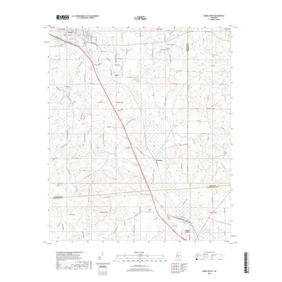
2018 Map of Magee South
USGS Topo · Published 2018About this map
Magee and Mount Olive anchor the northern and southern corridors of this Simpson County region, connected by the central settlements of Coats and Saratoga. The landscape is defined by the drainages of Okatoma Cr and its tributaries, including Uspoha Cr, Goodwater Cr, and McLaren Cr. A legacy of local industry is visible at McNair Millpond, while the rural character of the area is preserved in numerous family and community landmarks. Researchers can identify several spiritual and memorial sites, such as Siloam Church, Mount Moriah Church, and Sharon Church, alongside more secluded locations like McNair Cem and Tom Sullivan Cem. The map provides a look at the transition from the city streets of Magee, including Laurel Dr and Pinola Dr, to the winding rural routes of Saratoga Sharon Rd and New Hope Rd that traverse the pine-dominated terrain of central Mississippi.
Find a feature on this map
87 named features on this map. Tap any name to fly to it.
Don’t see what you’re looking for? This feature index may not catch every label — zoom into the map to look around manually.
Map Details
Editions of this 2018 Magee South Map
This is the sole edition of this map. No revisions or reprints were ever made.
Other maps of this area

1953 · Hattiesburg
USGS Topo · 1:250,000

1958 · Hattiesburg
USGS Topo · 1:250,000

1970 · Mendenhall East
USGS Topo · 1:24,000

1970 · Mount Carmel
USGS Topo · 1:24,000
1971 · Mendenhall SE
USGS Topo · 1:24,000

1974 · Lone Star
USGS Topo · 1:24,000

1974 · Collins
USGS Topo · 1:24,000
1975 · Cohay
USGS Topo · 1:24,000

1975 · Mize
USGS Topo · 1:24,000
1975 · Magee North
USGS Topo · 1:24,000