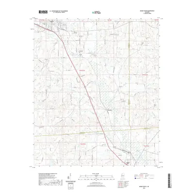
2020 Map of Magee South
USGS Topo · Published 2020About this map
Magee serves as the northern anchor for this 2020 landscape, where the town grid transitions into the rolling terrain of south-central Mississippi. The area is defined by a dense network of local roads and family-named landmarks that speak to the region's deep-rooted community ties. Coats and Saratoga stand as notable collection points for local history, situated along the primary transportation corridors that cross the county lines.
Find a feature on this map
116 named features on this map. Tap any name to fly to it.
Don’t see what you’re looking for? This feature index may not catch every label — zoom into the map to look around manually.
Map Details
Editions of this 2020 Magee South Map
This is the sole edition of this map. No revisions or reprints were ever made.
Other maps of this area

1953 · Hattiesburg
USGS Topo · 1:250,000

1958 · Hattiesburg
USGS Topo · 1:250,000

1970 · Mendenhall East
USGS Topo · 1:24,000

1970 · Mount Carmel
USGS Topo · 1:24,000
1971 · Mendenhall SE
USGS Topo · 1:24,000

1974 · Lone Star
USGS Topo · 1:24,000

1974 · Collins
USGS Topo · 1:24,000
1975 · Cohay
USGS Topo · 1:24,000

1975 · Mize
USGS Topo · 1:24,000
1975 · Magee North
USGS Topo · 1:24,000