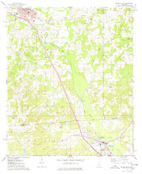
1975 Map of Magee South
USGS Topo · Published 1978About this map
The Illinois Central Gulf railroad forms a straight diagonal spine through the heart of this landscape, connecting the growing hub of Magee with the northern edge of Mount Olive. This mid-1970s view captures a rural terrain defined by the broad floodplain of Okatoma Creek and its many tributaries, such as Goodwater Creek and Uspoka Creek. A notable historical detail is the Old Indian Treaty Boundary, which cuts across the southern portion of the sheet near McNair Millpond, marking a legacy of early land divisions.
Find a feature on this map
49 named features on this map. Tap any name to fly to it.
Don’t see what you’re looking for? This feature index may not catch every label — zoom into the map to look around manually.
Map Details
Editions of this 1975 Magee South Map
This is the sole edition of this map. No revisions or reprints were ever made.
Other maps of this area

1953 · Hattiesburg
USGS Topo · 1:250,000

1958 · Hattiesburg
USGS Topo · 1:250,000

1970 · Mendenhall East
USGS Topo · 1:24,000

1970 · Mount Carmel
USGS Topo · 1:24,000
1971 · Mendenhall SE
USGS Topo · 1:24,000

1974 · Lone Star
USGS Topo · 1:24,000

1974 · Collins
USGS Topo · 1:24,000
1975 · Cohay
USGS Topo · 1:24,000

1975 · Mize
USGS Topo · 1:24,000
1975 · Magee North
USGS Topo · 1:24,000