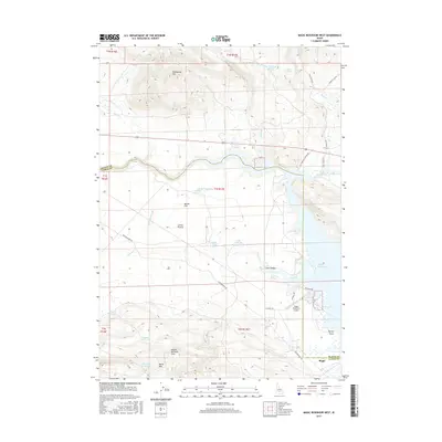
2017 Map of Magic Reservoir West
USGS Topo · Published 2017About this map
Magic Reservoir serves as the central focal point for this high-desert landscape where the Big Wood River meets the expansive southern Idaho plains. The map illustrates a transition from the volcanic and mountainous terrain of Moonstone Mtn and the Mount Bennett Hills down to the alluvial floor of the Camas Prairie and Macon Flat. The shorelines of the reservoir are marked by distinctive landmarks like Myrtle Point and the small settlement of Magic, which is supported by the Magic Reservoir Airport. Local water management is evident through a network of small upland impoundments such as Magpie Reservoir, Grouse Reservoir, and Floyds Reservoir. Geologic features like Lava Canyon and numerous springs, including Roseberry Springs and Cold Spring, underscore the hydrologic complexity of this volcanic region.
Find a feature on this map
47 named features on this map. Tap any name to fly to it.
Don’t see what you’re looking for? This feature index may not catch every label — zoom into the map to look around manually.
Map Details
Editions of this 2017 Magic Reservoir West Map
This is the sole edition of this map. No revisions or reprints were ever made.
Other maps of this area

1955 · Hailey
USGS Topo · 1:250,000

1957 · Thorn Creek
USGS Topo · 1:62,500

1957 · Bellevue
USGS Topo · 1:62,500

1957 · Blaine
USGS Topo · 1:62,500

1957 · Bellevue
USGS Topo · 1:24,000

1959 · Hailey
USGS Topo · 1:250,000

1962 · Hailey
USGS Topo · 1:250,000

1979 · Shoshone Ice Cave
USGS Topo · 1:24,000

1979 · Summit Reservoir
USGS Topo · 1:24,000
1986 · Bellevue
USGS Topo · 1:24,000