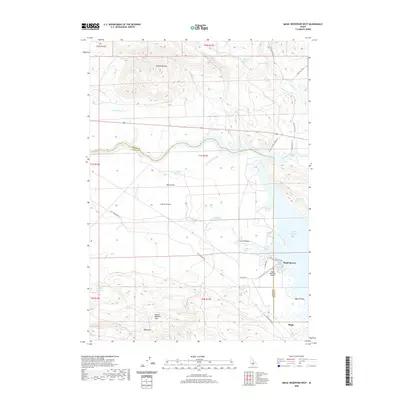
2020 Map of Magic Reservoir West
USGS Topo · Published 2020About this map
Camas Prairie and the volcanic landscape of the Mount Bennett Hills dominate this portion of the Idaho high desert. The map captures the hydrological network centered around the Magic Reservoir, where the Big Wood River and Camas Creek converge. A distinct boundary between Blaine and Camas Counties bisects the area, marked by a series of sloughs and springs like Northside Slough and Northside Spring.
Find a feature on this map
49 named features on this map. Tap any name to fly to it.
Don’t see what you’re looking for? This feature index may not catch every label — zoom into the map to look around manually.
Map Details
Editions of this 2020 Magic Reservoir West Map
This is the sole edition of this map. No revisions or reprints were ever made.
Other maps of this area

1955 · Hailey
USGS Topo · 1:250,000

1957 · Thorn Creek
USGS Topo · 1:62,500

1957 · Bellevue
USGS Topo · 1:62,500

1957 · Blaine
USGS Topo · 1:62,500

1957 · Bellevue
USGS Topo · 1:24,000

1959 · Hailey
USGS Topo · 1:250,000

1962 · Hailey
USGS Topo · 1:250,000

1979 · Shoshone Ice Cave
USGS Topo · 1:24,000

1979 · Summit Reservoir
USGS Topo · 1:24,000
1986 · Bellevue
USGS Topo · 1:24,000