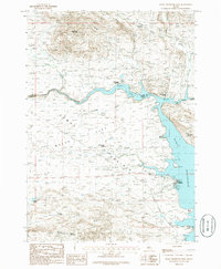
1986 Map of Magic Reservoir West
USGS Topo · Published 1986About this map
Camas Prairie dominates this Idaho landscape during the mid-1980s, revealing a region defined by its water resources and recreation. The sprawling Magic Reservoir serves as a focal point, fed by the Big Wood River and Camas Creek. Along its northern shores, small settlements such as Moonstone Landing, Hot Springs Landing, and Magic Resort mark the seasonal activity of the era, supported by infrastructure like a Landing Strip and Trailer Parks.
Find a feature on this map
36 named features on this map. Tap any name to fly to it.
Don’t see what you’re looking for? This feature index may not catch every label — zoom into the map to look around manually.
Map Details
Editions of this 1986 Magic Reservoir West Map
This is the sole edition of this map. No revisions or reprints were ever made.
Other maps of this area

1955 · Hailey
USGS Topo · 1:250,000

1957 · Thorn Creek
USGS Topo · 1:62,500

1957 · Bellevue
USGS Topo · 1:62,500

1957 · Blaine
USGS Topo · 1:62,500

1957 · Bellevue
USGS Topo · 1:24,000

1959 · Hailey
USGS Topo · 1:250,000

1962 · Hailey
USGS Topo · 1:250,000

1979 · Shoshone Ice Cave
USGS Topo · 1:24,000

1979 · Summit Reservoir
USGS Topo · 1:24,000
1986 · Bellevue
USGS Topo · 1:24,000