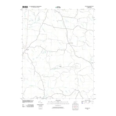
2010 Map of Magnolia
USGS Topo · Published 2010About this map
Magnolia and Mount Sherman serve as the primary nodes of settlement in this part of Larue County, where the landscape is defined by a dense network of creek branches and agricultural road systems. The area is characterized by its drainage into Lynn Camp Creek and Bacon Creek, which carve through the terrain alongside numerous smaller tributaries like Walters Creek and Pottinger Creek. A significant industrial feature is the Magnolia Gas Storage Field, which occupies a central portion of the quadrangle north of Die-Shiboley Church Rd. Local history and genealogy are preserved at the Dezarn Cemetery and Russell Cemetery, while the name Aetna Furnace near the southern border points to the region's earlier industrial heritage in iron production.
Find a feature on this map
54 named features on this map. Tap any name to fly to it.
Don’t see what you’re looking for? This feature index may not catch every label — zoom into the map to look around manually.
Map Details
Editions of this 2010 Magnolia Map
This is the sole edition of this map. No revisions or reprints were ever made.
Other maps of this area

1934 · Munfordville
USGS Topo · 1:48,000

1935 · Elizabethtown
USGS Topo · 1:48,000

1937 · Munfordville
USGS Topo · 1:62,500

1938 · Elizabethtown
USGS Topo · 1:62,500

1949 · Tonieville
USGS Topo · 1:24,000
1949 · Elizabethtown
USGS Topo · 1:62,500

1953 · Howardstown
USGS Topo · 1:24,000

1953 · Hudgins
USGS Topo · 1:24,000

1953 · Hibernia
USGS Topo · 1:24,000

1953 · Summersville
USGS Topo · 1:24,000