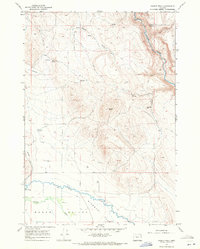
1967 Map of Magpie Peak
USGS Topo · Published 1971About this map
Magpie Peak stands as the central high point of this 1960s survey, overlooking a landscape defined by the critical management of water in the high desert. To the south, the Baker Valley opens into the broad expanse of Missouri Flat, where a complex network of irrigation and drainage infrastructure is visible. Features like the Swinger Ditch, Baldock Slough, and Mid Slough reflect the agricultural engineering required to support ranching and farming in this arid region of Eastern Oregon.
Find a feature on this map
21 named features on this map. Tap any name to fly to it.
Don’t see what you’re looking for? This feature index may not catch every label — zoom into the map to look around manually.
Map Details
Editions of this 1967 Magpie Peak Map
2 editions found
Other maps of this area

1901 · Baker City
USGS Topo · 1:125,000

1906 · Telocaset
USGS Topo · 1:125,000

1955 · Baker
USGS Topo · 1:250,000

1955 · Grangeville
USGS Topo · 1:250,000

1959 · Baker
USGS Topo · 1:250,000

1959 · Grangeville
USGS Topo · 1:250,000

1965 · Medical Springs
USGS Topo · 1:24,000
1965 · North Powder
USGS Topo · 1:24,000
1965 · Telocaset
USGS Topo · 1:24,000

1967 · Virtue Flat
USGS Topo · 1:24,000