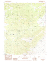
1987 Map of Magruder Mtn
USGS Topo · Published 1987About this map
The Palmetto Mountains dominate this high-desert region of Esmeralda County, where mining activity and remote springs define the landscape. The settlement of Palmetto sits along Lida Wash, serving as a central point in a topography marked by industrial extraction, notably at the Blue Dick Mine and several scattered Open Pit Mines. For historians and researchers, the map documents the essential water infrastructure of the Great Basin, including Mammoth Springs, State Line Springs, and Stockade Spring. Movement through this high-altitude terrain is channeled by landmarks such as Lida Summit and more isolated features like the Kline Spring Corral. To the southeast, the terrain descends toward the Lida Valley, while a remote Landing Strip suggests the scale and isolation of these high-desert operations.
Find a feature on this map
19 named features on this map. Tap any name to fly to it.
Don’t see what you’re looking for? This feature index may not catch every label — zoom into the map to look around manually.
Map Details
Editions of this 1987 Magruder Mtn Map
This is the sole edition of this map. No revisions or reprints were ever made.
Other maps of this area

1898 · Silver Peak
USGS Topo · 1:125,000

1900 · Silver Peak
USGS Topo · 1:125,000

1908 · Lida
USGS Topo · 1:250,000

1913 · Lida
USGS Topo · 1:250,000

1945 · Goldfield
USGS Topo · 1:125,000

1954 · Goldfield
USGS Topo · 1:250,000

1955 · Goldfield
USGS Topo · 1:250,000

1957 · Magruder Mtn
USGS Topo · 1:62,500

1958 · Goldfield
USGS Topo · 1:250,000

1962 · Goldfield
USGS Topo · 1:250,000