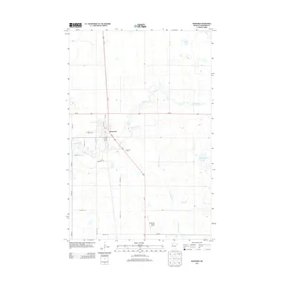
2013 Map of Mahnomen
USGS Topo · Published 2013About this map
Mahnomen serves as the central hub of this 2013 survey, where the intersection of Us-59 and MN-200 anchors the town's grid. The geography is defined by the winding paths of the Wild Rice River and White Earth River, which snake through a landscape dotted with small bodies of water like Gardner Lake and Rush Lake. This modern topographic study captures the essential infrastructure of the county seat, from the Mahnomen County Airport in the south to the local Po downtown. For those tracing family histories or local heritage, the map clearly identifies several burial grounds including First Lutheran Cem, Saint Michaels Cem, and Riverside Cem. The surrounding township roads, such as TWP HWY 80 and TWP HWY 95, reveal a structured agricultural layout typical of the Red River Valley region.
Find a feature on this map
41 named features on this map. Tap any name to fly to it.
Don’t see what you’re looking for? This feature index may not catch every label — zoom into the map to look around manually.
Map Details
Editions of this 2013 Mahnomen Map
This is the sole edition of this map. No revisions or reprints were ever made.
Other maps of this area

1918 · Flom
USGS Topo · 1:62,500

1952 · Grand Forks
USGS Topo · 1:250,000

1954 · Bemidji
USGS Topo · 1:250,000

1956 · Grand Forks
USGS Topo · 1:250,000

1957 · Bemidji
USGS Topo · 1:250,000

1958 · Bemidji
USGS Topo · 1:250,000

1966 · Grand Forks
USGS Topo · 1:250,000
1966 · Flom NE
USGS Topo · 1:24,000
1966 · Faith
USGS Topo · 1:24,000
1966 · Faith NE
USGS Topo · 1:24,000