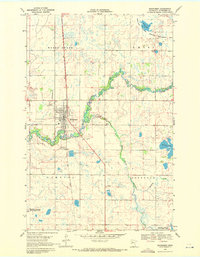
1969 Map of Mahnomen
USGS Topo · Published 1972About this map
Mahnomen serves as the focal point of this 1969 survey, situated at the intersection of the Soo Line railroad and local transport routes. The town’s social and civic fabric is visible through the County Fairgrounds, the Mahnomen County Country Club, and the localized Drive-in Theater. Genealogists will find several burial grounds including First Lutheran Cem, Riverside Cem, and St Michaels Cem.
Find a feature on this map
24 named features on this map. Tap any name to fly to it.
Don’t see what you’re looking for? This feature index may not catch every label — zoom into the map to look around manually.
Map Details
Editions of this 1969 Mahnomen Map
This is the sole edition of this map. No revisions or reprints were ever made.
Other maps of this area

1918 · Flom
USGS Topo · 1:62,500

1952 · Grand Forks
USGS Topo · 1:250,000

1954 · Bemidji
USGS Topo · 1:250,000

1956 · Grand Forks
USGS Topo · 1:250,000

1957 · Bemidji
USGS Topo · 1:250,000

1958 · Bemidji
USGS Topo · 1:250,000

1966 · Grand Forks
USGS Topo · 1:250,000
1966 · Flom NE
USGS Topo · 1:24,000
1966 · Faith
USGS Topo · 1:24,000
1966 · Faith NE
USGS Topo · 1:24,000