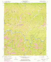
1964 Map of Majestic
USGS Topo · Published 1978About this map
The Tug Fork carves a winding path through the borderlands of West Virginia and Kentucky, anchoring a landscape defined by coal extraction and narrow valley settlements. In the mid-1960s, the Norfolk and Western railroad followed the river's tight bends, serving industrial nodes like Thacker Mines and Vulcan. The topography is dominated by numerous strip mines and complex drainage systems, including Grapevine Creek and Mate Creek, which dictate the placement of local infrastructure. Small mountain communities and rural outposts such as Devon, Majestic, and Stopover are connected by these rails and waterways. Local life is further evidenced by small schools and churches tucked into the hollows, including Thacker Sch and Turkey Fork Sch, reflecting the decentralized nature of Appalachian mining society during this era of heavy industrial activity.
Find a feature on this map
84 named features on this map. Tap any name to fly to it.
Don’t see what you’re looking for? This feature index may not catch every label — zoom into the map to look around manually.
Map Details
Editions of this 1964 Majestic Map
3 editions found
Other maps of this area

1886 · Grundy
USGS Topo · 1:125,000

1887 · Warfield
USGS Topo · 1:125,000

1890 · Grundy
USGS Topo · 1:125,000

1891 · Tazewell
USGS Topo · 1:125,000

1891 · Oceana
USGS Topo · 1:125,000

1891 · Warfield
USGS Topo · 1:125,000

1892 · Grundy
USGS Topo · 1:125,000

1893 · Oceana
USGS Topo · 1:125,000

1895 · Tazewell
USGS Topo · 1:125,000

1897 · Tazewell
USGS Topo · 1:125,000